| Stara Luka | |
|---|---|
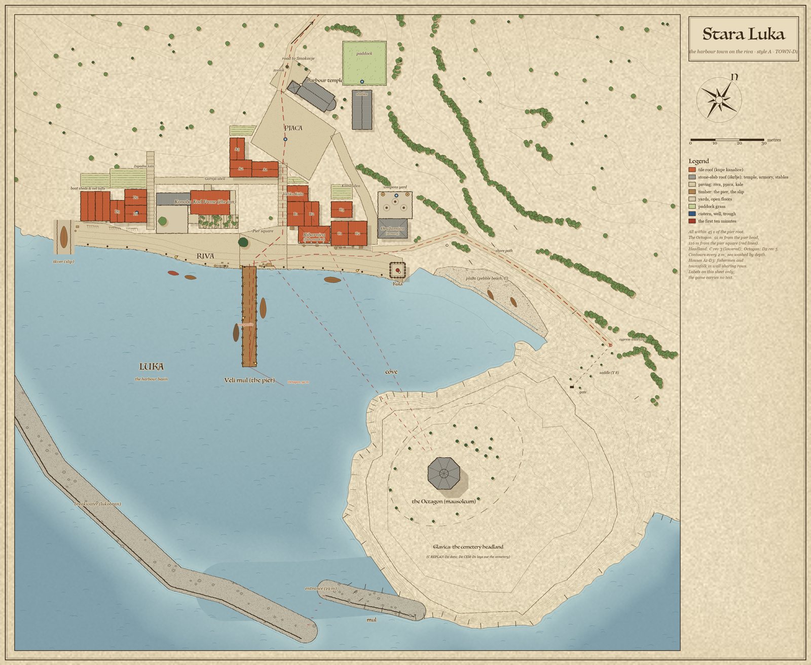 The town blueprint (TOWN-D1 rev 3.3) | |
| Type | Harbour town (fishing town) |
| Meaning | "Old harbour" |
| Location | Island 1, head of the S/SE bay |
| Regional style | A, Dalmatian/Istrian |
| Affiliation | The island's port; seat of the count (hall deferred) |
| Population | 12 named households plus the inn, temple, watch and trades |
| Economy | Sardines, salting, nets, boat building |
| Plan | stara_luka_town.md |
| Status | First demo level: plan READY; harbour front slice in Godot |
Stara Luka
Stara Luka ("old harbour") is a small fishing town on the south coast of Island 1, built in the Dalmatian/Istrian style. It faces its pier: a stone quay, a single timber pier, a square halfway up the valley with a temple and a bell tower, and across the harbour the haunted Glavica headland with its great mausoleum, the Octagon. It is the setting of LOAA's first demo level.
Overview
The town sits at the mouth of a dry valley (draga), the only near-flat ground on its headland's flank. Everything grows from the harbour:
- The Riva, a 10 m stone quay, runs 135 m along the water.
- The Veli mul, the town's single timber pier, leaves the riva at the pier square.
- Around the pier square stand the inn, Konoba Kod Frane, with its vine terrace; the fish market loggia; and the foot of the Velika kala, the grand stone stair.
- The Velika kala climbs straight up the valley to the pjaca, the main square, with the harbour temple, its campanile and the public cistern.
- Behind the square are the stables and paddock. A cart street winds down from them to the riva.
- At the riva's east tip, where the harbour mouth opens and the shore path leaves for the headland, stand the armory and the kula watch tower with its beacon.
- Twelve houses of fishermen and townsfolk fill the gaps in four wall-sharing rows, with the boat sheds and the slip (škver) at the west end.
- In the inner corner of the harbour lies a pebble beach, and the breakwater and the mul close the basin to the south.
From the pier head you see the campanile up the kala on one side and the mausoleum across the cove on the other.
Districts and landmarks
| Place | What it is |
|---|---|
| Riva | the quay, 135 m, the town's front and a long fighting strip |
| Veli mul | the timber pier, the signature landmark |
| Pier square | 19.4 × 17.5 m, the heart of the harbour front |
| Fish market (Ribarnica) | the open loggia where the catch is sold at dawn |
| Pjaca | the main square, 31.1 × 24.4 m, with the temple and cistern |
| Harbour temple and campanile | the town's landmark; the tower tops out at Y 27 |
| Armory and kula | the watch at the harbour mouth, with a weapons yard |
| Stables | the carters' yard, stable and paddock |
| Beach | a 61 m pebble pocket beach |
| Breakwater and mul | the rubble breakwater (lukobran) and the short mole |
| Boat sheds and škver | net lofts and a slip with a hull on the stocks |
Streets
| Name | Kind | Width | Notes |
|---|---|---|---|
| Riva | quay | 10 m band | level, dressed limestone slabs, bollards every 8 m |
| Velika kala ("the grand stair") | stepped lane | 3.6 m | about 37 steps up to the pjaca |
| Zapadna kala ("west stair") | stepped lane | 3.0 m | up into the olive terraces |
| Gornja ulica ("upper lane") | lane | 3.0 m | along the contour behind the inn |
| Kolna ulica ("cart street") | street | 4.0 m | winds from the stables to the riva at 13.5 % |
| Harbour road | cart road | 3.5 m | up to Smokovje |
| Shore path | path | 2.4 m | 114 m round the cove to the cemetery's cypress walk |
The stepped lanes (kale) carry no carts, which is true to the period. The main loop takes about three minutes: pier → pier square → Velika kala → pjaca → cart street → east riva → back west past the market and the inn → boat sheds → Zapadna kala → upper lane → down the Velika kala.
People
Every household is tied to a trade the harbour needs: the net-maker, the cooper, the sailmaker, the salters, the caulker, the chandler, the harbour master, skipper families (one owns the leut Galeb), the temple keeper and the watch sergeant. See Townsfolk of Stara Luka.
Life: fishmongers at dawn, net-menders on the west riva, sentries on the kula, carters in the stable yard, children on the Velika kala; gulls on the market roof and the pier posts, cats at the market, mules and horses in the paddock, the inn's dog. Smoke rises from the inn's two flues, the cooper's fire and the tar pots. You hear the bell, gulls and slapping water, hammering at the slip, and the watch at drill.
Wind, water and why the town is here
- Water: there is no spring. Every house has a roof cistern, and the pjaca has the public cistern. The valley's winter torrent runs in a culvert under the square.
- Wind: the maestral blows down the valley to the sea, so the fish market and the slip sit on the quay and at the west edge. The temple's blind north wall faces the bura.
- Sun: the riva faces SSE and has sun all day, so shade is placed where people work: the market roof, the inn's vine pergola, the pier-square pine.
The first ten minutes
- Arrive on the road from Smokovje; the campanile and the temple's west front close the view.
- The pjaca: the cistern, the temple door, the temple keeper.
- Down the Velika kala to the pier square: the fish market on the left, the inn's terrace on the right.
- Out along the pier: at its head the cove opens, and the mausoleum stands on the far headland.
- Back along the east riva: the chandler, the armory and the kula. The sergeant sends the party along the shore path to the cemetery. The first fight can be a drill in the weapons yard.
Views of the Octagon
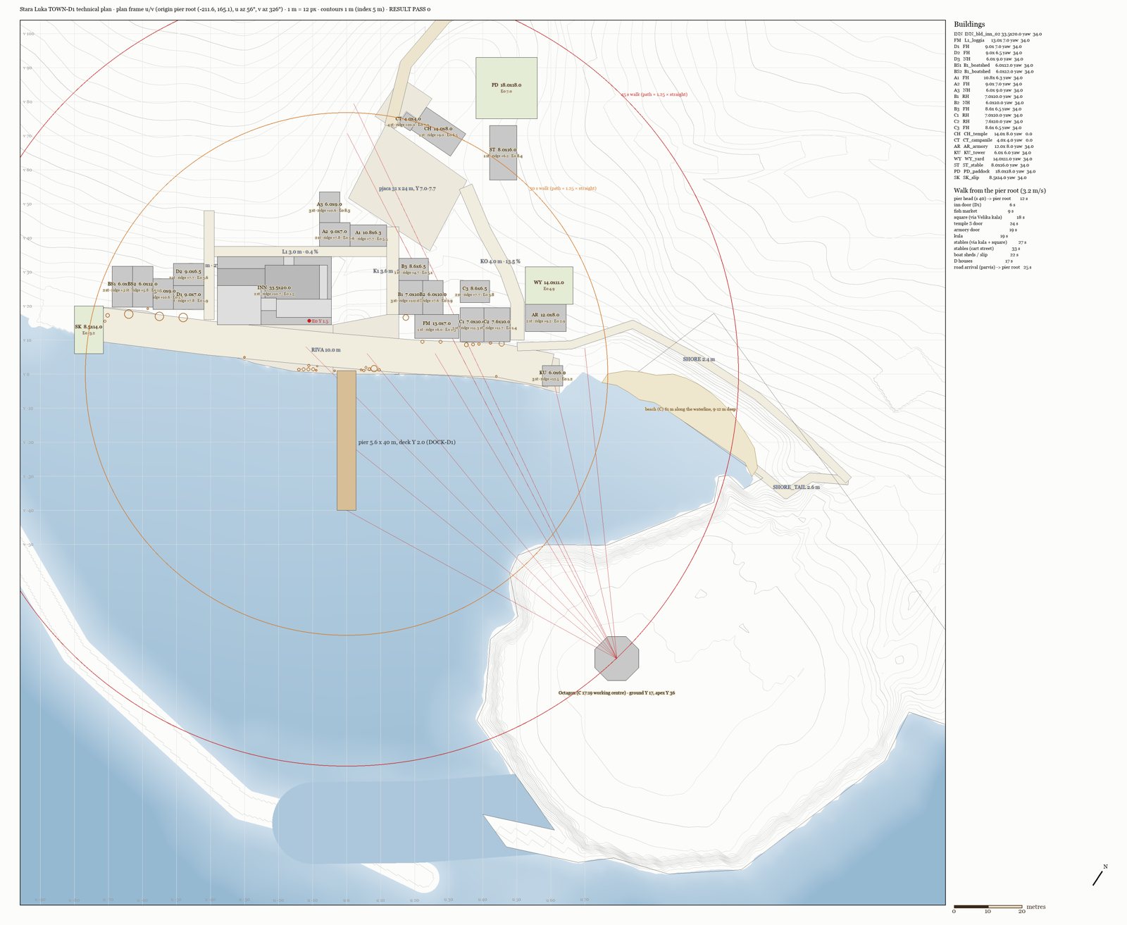
The Octagon is 91 m from the pier head, 116 m from the pier square and 151 m from the pjaca cistern. Two houses under the pjaca were kept low (a two-storey house and a one-storey cottage) so the Octagon stays visible from the square. At night the kula's beacon and the Octagon's single lamp answer each other across the harbour.
History
Planned as the island's port and the seat of the count, Stara Luka was recast fishing-first for the demo (sardines, salting, nets, boat building). The count's hall is deferred. Its dead are buried across the water on the Glavica. See History of Island 1.
Development
- Plan: TOWN-D1 rev 3.3, READY (architect), generated by
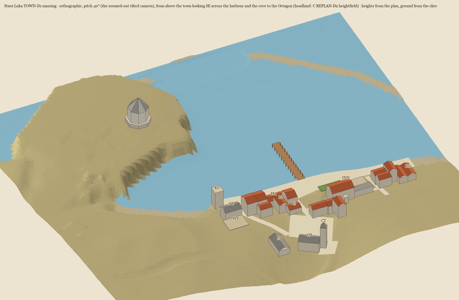
stara_luka_town_plan.py(RESULT PASS 0). Earlier whole-town plan (rev 1, 37 buildings) kept as reference. - Built so far: the inn slice down to the riva and the pier root, in the painted style (waves 2026-09-28p and 2026-09-29c).
- Phasing: P1 the harbour front → P2 the pjaca and temple → P3 the watch → P4 the edges.
| Blueprint | Technical plan | Massing |
|---|---|---|
|
 |
 |
See also
Sources: docs/towns/island1/stara_luka_town.md (rev 3.3); docs/plan/level_02_fishing_town_plan.md; docs/towns/island1/settlements.md; docs/project-summary.md Last updated: 2026-09-29 (WIKI-1)